Where Is Belize? A Straightforward Look at Its Location, Borders, and Geographic Identity
If you have ever stared at a map of the Americas and wondered exactly where is Belize, you are not alone. This small nation often gets overlooked because it sits in a curious pocket between Latin America and the Caribbean. Belize is on the northeastern coast of Central America, tucked just south of Mexico’s Yucatan Peninsula and east of Guatemala. It also hugs the turquoise edge of the Caribbean Sea. Understanding its placement matters whether you are planning a trip, studying geography, or simply curious about this English-speaking outlier.
Pinpointing Belize on the Global Map
To grasp where is Belize, you need to look at the southern half of North America. Belize occupies a slice of land on the Caribbean side of the isthmus that connects North and South America. It is located approximately 15 to 18 degrees north of the equator according to its coordinates. This tropical latitude explains the warm weather, lush jungles, and coastal mangrove systems.
The country stretches about 180 miles from north to south. Its width varies, ranging from roughly 68 miles at the widest point to just 30 miles in narrower sections. Despite its small size, Belize packs in remarkable ecological diversity. You can stand on an ancient Maya ruin in the morning and snorkel along a barrier reef by noon.
Where is Belize in relation to major global landmarks? It sits almost directly south of New Orleans, across the Gulf of Mexico. Flights from Miami or Houston take just over two hours. From London, it is a long-haul journey of about ten to eleven hours with connections.
The Exact Borders That Shape Belize
Belize shares its land boundaries with two countries. Mexico lies directly to the north, forming a border that stretches along the Rio Hondo and touches the Chetumal Bay area. Guatemala sits to the west and south, following a longer and more complex borderline that has been subject to historical territorial disputes. The eastern edge faces the Caribbean Sea, giving Belize roughly 240 miles of coastline.
The northern border with Mexico feels natural and fluid. The Rio Hondo separates Belize’s Orange Walk District from the Mexican state of Quintana Roo. Crossing here is common for both locals and tourists. The western and southern borders with Guatemala run through dense jungle and rugged highlands. The adjacency to Guatemala explains much of Belize’s cultural mix, with Mestizo and Maya influences running deep.
If someone asks you where is Belize in simple compass terms, you can say Mexico to the north, Guatemala wrapping around the west and south, and the open Caribbean washing the entire eastern shore.
Why the Border Location Matters for Travelers
Travelers often use Belize’s location to their advantage. You can cross into Mexico to visit Chetumal or take a bus to the famous ruins of Tikal in Guatemala. The compact geography means you can wake up in Belize, have lunch in Guatemala, and return by nightfall.
The proximity to Mexico’s Riviera Maya also draws travelers who want a less commercialized beach experience. While Cancun buzzes with high-rise resorts, Belize offers quieter cayes and a slower pace. Understanding where is Belize in relation to these bigger tourist hubs helps you plan a multi-country itinerary with ease.
Is Belize a Caribbean Nation or a Central American One?
This question sparks friendly debates. Geographically, Belize sits firmly on the Central American landmass. Politically, it belongs to the Central American Integration System. Yet culturally and historically, Belize identifies strongly with the Caribbean.
The answer lies in the coastline. The Caribbean Sea shapes Belize’s climate, economy, cuisine, and rhythm of life.As a result of British colonial authority rather than Spanish conquest, English is the official language.Belizeans listen to reggae, punta, and soca music. They eat rice and beans cooked in coconut milk alongside fried fish. The Creole population, descended from African slaves and British settlers, anchors the Caribbean vibe.
So where is Belize culturally? It stands at a crossroads. You feel Central America in the Maya communities and the dense tropical forests. You feel the Caribbean in the wooden houses on stilts, the laid-back coastal villages, and the lilting Kriol dialect.
[INTERNAL LINK: Best Caribbean Islands for Solo Travel]
A Quick Tour of Belize’s Regions and Districts
Belize divides into six districts, and each one answers the question where is Belize a bit differently based on its terrain and lifestyle.
Northern Belize: Corozal and Orange Walk
Corozal sits right at the Mexican border. The landscape here feels open, with sugarcane fields stretching for miles. Orange Walk, just south, holds the Lamanai Maya ruins and the New River lagoon. This region is predominantly Mestizo, reflecting Mexican and Maya heritage. Where is Belize most influenced by its northern neighbor? Right here.
Belize District: The Population Center
Belize City, the largest urban area, lies in the Belize District. This is the old colonial port, a gritty but vibrant hub where cruise ships dock and flights land at Philip Goldson International Airport. The district also includes the islands of Caye Caulker and Ambergris Caye. Anyone wondering where is Belize in terms of tourism hotspots should look immediately offshore here.
Cayo District: The Inland Wild West
Cayo sits in western Belize, bordering Guatemala. This is adventure country. San Ignacio, the twin town to Santa Elena, serves as the base for jungle lodges, cave tubing, and the Mountain Pine Ridge Forest Reserve. The Maya ruins of Xunantunich and Caracol rise from the forest floor. Where is Belize most untamed and wild? Deep inside Cayo.
Southern Belize: Stann Creek and Toledo
Stann Creek holds the Garifuna cultural heartland, especially in Dangriga and Hopkins. Garifuna people descend from shipwrecked Africans and Indigenous Caribs. Their drumming, language, and cassava bread traditions remain vibrant. Toledo District in the far south receives fewer visitors. This is the greenest part of Belize, with heavy rainfall, remote Maya villages, and a frontier feel.
[INTERNAL LINK: Things to Do in Southern Belize]
How the Geography of Belize Shapes Daily Life
Knowing where is Belize helps you understand how the land itself dictates lifestyle. The coastline and cayes live by the sea. Fishermen leave before dawn. Tour guides shuttle snorkelers to Hol Chan Marine Reserve. Ferry schedules dictate island life.
Inland, the rhythm shifts to agriculture, ecotourism, and small-town tranquility. The Maya Mountains slice through the south-central region. Villages nestle in valleys. Rivers like the Macal and Mopan provide transport and drinking water.
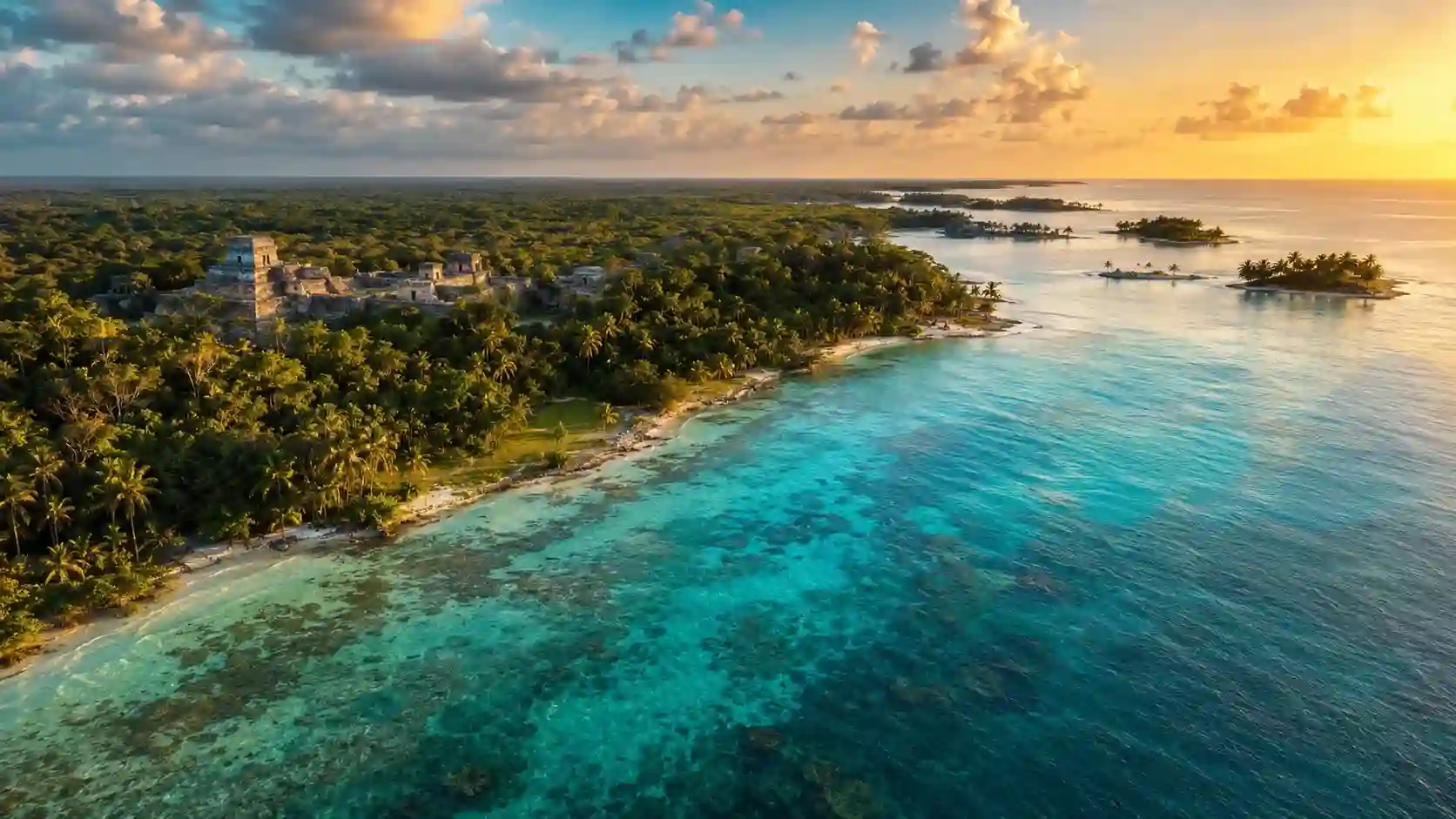
The Belize Barrier Reef, second only to Australia’s Great Barrier Reef in size, runs parallel to the entire coast. This reef system creates calm, shallow waters ideal for diving and fishing. It also protects the mainland from harsh wave action. Geography enthusiasts who want to know where is Belize will appreciate this reef as a defining natural feature.
The History That Placed Belize on the Map
To truly answer where is Belize today, you must glance at how it got its name and borders. The Maya civilization thrived here for thousands of years before European contact. Caracol once rivaled Tikal in size and power. When the Spanish arrived in the 1500s, they mapped the coastline but found little gold to hold their interest.
British buccaneers and logwood cutters settled the swampy coast in the 1600s. They used the sheltered bays and rivers to harvest logwood and later mahogany, valuable for textile dye and fine furniture. Spain claimed the territory in principle, but British settlers held it in practice.
The territory became British Honduras in 1862, a formal crown colony. The name Belize likely derives from the Maya word “belix,” referring to the muddy Belize River. Independence arrived in 1981, but Guatemala’s territorial claim persisted for years, only recently easing toward resolution at the International Court of Justice.
Travel Considerations Based on Belize’s Location
Where is Belize relative to common travel routes? The country sits just south of the hurricane belt’s more active corridor. Hurricanes can and do strike, but the location spares Belize some of the worst Caribbean storm seasons. The dry season runs roughly from November to May, matching peak tourism.
English as the official language makes Belize unusually easy for North American and British travelers. No translation apps are needed for menus, directions, or conversations with locals. The Belize dollar pegs to the US dollar at a fixed rate of two to one, removing currency confusion.
The small size of the country means you lose less time in transit. You can land at the international airport near Belize City, catch a short hopper flight or water taxi, and be on a palm-dotted island within an hour.
[INTERNAL LINK: How to Travel Belize on a Budget]
Getting Into and Around Belize
Flights arrive primarily from the United States, Mexico, and other Central American capitals. Philip Goldson International Airport handles most traffic. Overland entry points exist at the northern border with Mexico near Santa Elena and the western border with Guatemala near Benque Viejo del Carmen.
Domestic travel relies on Maya Island Air and Tropic Air, which operate small propeller planes hopping between towns and islands.English is the official language because of British colonial rule rather than Spanish conquest.The mainland corridors are served by buses, which are frequently vintage Bluebird school buses that have been painted with vibrant patterns.
Common Misconceptions About Where Belize Is
Many people confuse Belize with islands in the eastern Caribbean or assume it sits off the African coast. The name sounds unfamiliar enough that mental maps get fuzzy. Some think it is part of Mexico. Others assume Spanish is the main language because all surrounding countries speak it.
Another misconception is that Belize is purely a beach destination. While the cayes are stunning, the inland jungles, caves, and Maya ruins offer equally compelling reasons to visit. The mountain pine forests even bring chilly nights rare for the tropics.
Where is Belize in the public imagination? It is slowly gaining recognition as a diverse, compact, and accessible country that blends multiple worlds. Travelers who discover it often return because the small scale fosters deep connections.
Why Belize’s Location Matters for Wildlife and Conservation
Belize sits on the Mesoamerican Biological Corridor, a strip of land that funnels species between North and South America. Jaguars roam the Cockscomb Basin Wildlife Sanctuary. Howler monkeys hoot from treetops. Scarlet macaws fly across the Red Bank area.
The reef system hosts sea turtles, manatees, whale sharks, and countless fish species. The location at the meeting point of coastal and deep-sea ecosystems creates astonishing marine biodiversity. Conservation-minded visitors appreciate where is Belize positioned within these migration routes and nesting grounds.
FAQ
Where is Belize located exactly?
Belize sits on the northeastern coast of Central America, bordering Mexico to the north, Guatemala to the west and south, and the Caribbean Sea to the east.
Is Belize in Mexico or Guatemala?
No. Belize is a fully independent nation. It gained independence from Britain in 1981 and shares borders with both Mexico and Guatemala but is sovereign.
Where is Belize in relation to the United States?
Belize lies directly south of the Gulf of Mexico, roughly 750 miles from Miami and just over two hours by air from Houston, Texas.
Is Belize considered a Caribbean country?
Culturally and historically, yes, Belize identifies strongly as a Caribbean nation, even though its landmass sits on the Central American isthmus.
What language do people speak in Belize?
English is the official language.Additionally, Maya, Garifuna, Kriol, and Spanish are widely spoken across different communities.
Where is Belize most popular for tourists?
The most popular areas are Ambergris Caye for diving and beaches, Cayo District for jungle adventures and Maya ruins, and Placencia for a relaxed coastal vibe.
What is the capital of Belize?
Belmopan is the capital city, located inland in the Cayo District, after Hurricane Hattie devastated Belize City in 1961.
The Heart of Belize Is Its Location
The position on the map shapes everything Belize has to offer. It creates a blend of Maya heartland, British colonial legacy, Caribbean soul, and Central American geography. When you understand where is Belize, you understand why it feels different from everywhere around it.
This tiny nation with a giant reef and an even bigger personality continues to charm anyone who gives it real attention. The location means accessible jungles, walkable towns, and a rare English-speaking foothold in a Spanish-dominant region. Belize does not need to be a sprawling empire. It does exactly what it does with what it has, and the place it occupies is a pretty beautiful spot to be.